Showing posts with label Volcano. Show all posts

Sunday, 6 March 2011

Krisuvik comparison


Just been looking at the latest swarm activity around Krisuvik, Iceland. The activity seems to be migrating away from Kleiforvatn under the lava fields to the West. Depth seems to have retreated to the 3-7km level, so for the moment, until any other developments are forthcoming, I'd say the threat of an immediate eruption is receding.

There's been a little shallowish grumbling under Grimsvotn which might indicate a minor eruption will be underway shortly. This is nothing unusual, and generally results in glacial floods as lava melts the ice above.

I'm still hacking away at a post about the planet and electromagnetism, but every time I try, there's been a new development. So, back to the drawing board.

I'm also feeling more tired than usual. Mrs S is back from hospital, and I spend the time I'm not at my new job running errands and generally making sure she's comfortable. It's also playing havoc with my sleep pattern, which isn't too wonderful as I'm currently working in shifts (and very pretty I look, too).

Hi ho. Time for bed. Zzzzzzzzzzz.

Sunday, 27 February 2011

'Flux ropes' and power generation

Two Russian researchers, Boyarchuk and Pulinets, posited back in 2004 that flares and associated Solar electromagnetic phenomena might induce Earth tremors and perhaps extra heat within the Earth’s nickel iron core. More recently, (2007) the NASA THEMIS experiment detected things dubbed 'flux ropes', or concentrations of electromagnetic force linking the Sun and the Earth. The net effect of these variations has, so I'm told, a minor effect on the inner Earth, and increasing convection of magma within the inner and outer mantle, rather like happens in boiling water. The extra energy venting itself via various volcanic outlets like ‘black smokers’ down in the various oceanic spreading zones, Volcanoes, and the melting of rock in subduction zones. At present there are no certain proofs in the public domain although such an induced heating effect is in line with electromagnetic theory, and can be observed under experimental conditions.

As an aside; this core heating effect is probably also why Venus has such a hellish corrosive soup for an atmosphere. Venus is, like Earth, thought to have a nickel iron core, and this is thought to be heated vigorously by its passage through the more tightly packed magnetic field closer to the Sun. As I've posted previously, volcanism is the culprit for Venus' atmosphere, definitely not CO2. For example if CO2 was the culprit, Mars would be a lot warmer than it is, having a similar concentration of atmospheric CO2 (About 95.32%) to Venus (96.5%).

To get to the crux of the matter; my friend Delcatto asked the question; “Could we harness the electromagnetic force from the Sun to provide power?”

My answer is ‘No’.

For the following reasons;
  1. The concentration of electromagnetic force, even at the poles, does not appear strong enough. If it were, then our biosphere would not be habitable, at least to us.
  2. Why? Because the Earth needs to have a molten core. Without it our fecund little world would be as dead as Mars. Life as we know it depends on a complex interplay of energies and forces requiring heat from both above (the Sun) and below (the Earth), which is what allows our fragile little 10 kilometer deep biosphere to exist, sandwiched between a figurative heaven and hell. Significantly reduce the heating effect of the Earth’s core, as would happen if enough of the electromagnetism at the poles were diverted for power generation, and, to put it bluntly, life on Earth would be (Eventually) buggered.
  3. To get sufficient concentration of force lines for power generation, you have to divert them from somewhere else into some kind of collector ring. It would not be a good idea to stick such a device over the polar regions of Earth, see reason 2, but near Venus to power something like a wormhole portal for interstellar travel? There’s an intriguing thought. If such a device were possible, power transmission issues would render transfer to Earth less than useful (Until some clever dicky rewrites the physics of power transmission that is). Venus would ‘benefit’ from the reduction in volcanism due to a cooler core and perhaps eventually become borderline habitable, or at least not quite so hostile as at present. However, such a cooling process would require (at the very least) a couple of million years. So, no panic there, then.
Which just gave me an absolutely spiffing idea for another science fiction story. Ta muchly.

Krisuvik swarm: count 356....er 425

In the screengrab, which is representative rather than definitive, as I couldn't be sure I was getting the whole lot on. The tremor count at the time of observation was 356 at 13:25 GMT in the last 48 hours. That is a hell of a busy weekend. I make it over 228 since midnight, local time and rapidly increasing. For preliminary data, that's going to keep someone busy.

Range of tremors is mostly 2+km depth on the third day of near continual swarm activity. No idea what this portends, apart from I'd still like some idea of what the water levels of Kleiforvatn are doing. It's still jaw meets desk territory.

More later today. This bears watching.

All data from Icelandic Met Office Earthquakes page.

Update: My goof. Count is 356, not 367. Revised.

Update: As of 15:00GMT 394 Tremors. That's a whole lot of shaking.

Added to top of sidebar: Christchurch Earthquake Appeal. Thanks to Small Dead Animals for highlighting the link.

Update: 425. Also peaking and shallowing. See data grab below.
Sunday
27.02.2011 17:27:36 63.928 -22.034 1.1 km 4.1 90.07 4.8 km NNE of Krýsuvík
Sunday
27.02.2011 17:25:21 63.920 -22.030 1.6 km 3.4 90.07 4.0 km NNE of Krýsuvík

Will be very surprised if something doesn't blow in the next 24-48 hours at this rate.

Update: 514 tremors in the Reykjanes peninsula area in the last 48 hours as of 22:25 GMT. Most close to Krisuvik.

Saturday, 26 February 2011

Krisuvik activity 2 day swarm

Have been looking at the latest activity under Krisuvik with a little more critical eye in the wake of the revelation that the swarms at Hengill were caused by water injection into heated strata by the power station people. Having compared and contrasted the screengrabs I took at the time, there's a definite similarity in depth and intensity.

As the Krisuvik field is close to the large lake called Kleifarvatn, I find myself wondering if there's currently some form of leakage into the fault complex that might be a causative factor. According to it's Wikipedia page entry the lake has leaked periodically since a big quake in 2000. Wonder what the water levels have been doing recently?

Friday, 25 February 2011

New Icelandic link

Courtesy of commenter Smiler03; a new treasure on the Volcanic matters blogroll. The Iceland Volcano and Earthquake blog.

He has the story about the recent Hengill tremor swarms being man made, and the juice behind the recent Krisuvik activity. Brief and to the point, with a better inside track than I could ever hope for.

Thursday, 24 February 2011

Grímsvötn grumbling

Just spotted this little grumble under Vatnajökull which is rather reminiscent of last years minor eruption and glacial floods.

Usual caveats about tremors and eruptions apply, so until someone can come up with a monitor that can measure the frequencies that theoretically indicate when a volcano is about to go foom, we're stuck with conjecture and old fashioned methods of measurement. I'm waiting to see what the big brains over at UBC are going to come up with.

Christchurch Quake distribution.

Regarding my post on the Christchurch Earthquakes. Here is a screengrab of published seismic activity during the last seven days in that area. From the 18th to the 25th February, New Zealand dates and times.

As I posited earlier, the majority of the activity, including the big ones, have all been located in a fairly tight geographical area in the north caldera wall of an extinct volcano. The dots show the epicentre of each tremor, colour coded for depth.

The thought occurs that if one side of a caldera shifts, that moves the stresses around, and it's only a matter of time before more tremors hit around the rest of the perimeter. When and where appear to be the only issues outstanding.

Wednesday, 23 February 2011

Christchurch, NZ

My comrade in words the Angry Exile brought this site to my attention which kind of tells a greater story about the Christchurch Earthquake than the one currently being covered in the mainstream.

Often when an Earthquake is reported, all you see are the headlines, like '200 people killed in quake horror' for example. When you read the associated articles, they skim over the surface, glossing over important details that might be actually useful, apart from generating mere sympathy for the victims. The really interesting thing about the Christchurch tremors is the concentration of seismic activity and where it is happening.

What really did the damage was not one big quake, like the 7.1 magnitude on the picture from 4th September 2010, but a series of rapid hammer blows of 3-4+ magnitude after the main shocks of 6.3 and 5.7, which occurred within twelve minutes of one another. They were followed by a 5.9 magnitude quake less than two hours later. If you run through the sequence of tremors, you can see that the vast majority of the recent shocks recorded are in what is known to be the northern caldera wall of an extinct volcano. Having run through the recent sequences, I'd hazard a guess that what is happening under the Southern edge of Christchurch is a widespread collapse of the old volcanic vent system and magma chambers in the 2-12km depth range. Perhaps even slippage in the faults within the caldera walls as they 'settle'. Not directly related to the nearby Greendale fault at all.

I'm only an amateur observer of such phenomena, but that's what it looks like to me. Go look for yourselves. Run the sequence of 22nd February and you'll see what I mean.

Eyjafjallajökull again.

A bunch of small tremors today just over a kilometre down under good old Mt Unpronounceable. Usual caveats apply about tremors and eruptions. Magma chamber could be draining, not filling, no data on ground deformation or tilt etcetera, etcetera. So as usual pretty inconclusive, but surprising nonetheless. Nothing on the local webcam. Just small, shallow(ish) tremors.

Not much worth getting excited about. For excitement, Kilauea, Hawaii is having a few collapses in the crater wall, and the lava lake is rising. Bulusan in the Phillipines has been erupting for the past couple of days. Plenty of 'excitement' there.

Reykjanes peninsula activity is still grumbling away, but going deeper, and scattered tremors through Vatnajökull.

Meanwhile, back here on Vancouver Island it's snowing. We have an extreme weather warning no less.

Sunday, 20 February 2011

Hellisheiði again


Two swarms in the past nine days near Hellisheiði. Todays activity is definitely shallower overall than nine days ago (See red underlined tremors in upper graphic.) First reported in this post.

Not sure what this means, but as there are webcams close by, if any activity does make it to the surface, we're in a very good position to see it happen on the Eastward facing camera of Highway 1 (See previous post on Hellisheiði.) As it is close to Icelands biggest geothermal power generating facility, I'm assuming that the guys at Hengill will be keeping a close eye on their seismographs too. Will check again first thing in the morning before I go to work.

Update: Tremor activity has slid back a little and the swarm seems at the time of writing to have diminished with most activity back down at the 2-5km level.

Saturday, 19 February 2011

Katla status 19th February 2011

Low level grumbling with a semi regular burbling every few hours from 100 metres to a kilometre and a bit down.

As usual, caveat about tremors alone do not indicate an eruption is either pending or not.

Wednesday, 16 February 2011

Mt St Helens

Reports of a small Earthquake swarm not far from Mt St Helens south of the border are coming in. Whether this develops further is on my list of things to watch. The swarm itself is reported at around approximately 2-5 kilometres depth. This sort of tremor activity is generally thought not to be indicative of eruption, just a little bit of subsurface rearranging of geological furniture.

Iceland is pretty quiet at the moment, seismically speaking. Considering where it sits on the mid Atlantic spreading zone, this is mildly surprising. However, I'm sure another swarm will be along in the next few days.

Tuesday, 15 February 2011

Volcano love

Power outage last night due to a bit of a storm, so no blogging. Picked up this little snippet about 'Love waves' from Mt St Helens. Named afte Geophysicist Augustus Edward Hough Love. No threat of eruption, just seismic grumbles like those of nearly 30 years ago which followed the famous 1980 eruption.

How appropriate for Valentines day.

Activity at Langjokull, Iceland has settled down to regular grumbles which probably mean nothing. Similar pattern under Katla. About as quiet on the Iceland front as it ever gets, tremor wise.

One of the things that has piqued my interest is a claimed correlation between solar flare geomagnetic activity and Volcanoes. Seeing as there was a big X flare yesterday on the Sun (The biggest since 2006), this postulation should soon be put to the test. Will be keeping a weather eye on various seismometers to see what truth may be found there.

Sunday, 13 February 2011

Video hinc domum tuam

Which means; "I can see your house from here."

Adding to the volcano links sidebar the Mt Baker Volcano observatory. This is an active volcano which is on my front doorstep. Well not quite. Ninety four miles away, but perfectly visible on any clear day. Active Volcanoes I can't see from my deck on a clear day are; Glacier Peak, Mt St Helens and Mt Rainier. That's Washington State in the USA. There are a couple of active Volcanoes in BC, but being British Columbian Volcanoes they're far too laid back to do much erupting. Mt Garibaldi for example, just up the road from Squamish, hasn't belched for around ten thousand years.

Not that any eruptions are thought to be immanent, but it's nice to know I would have a relatively safe ringside seat should Mt Baker decide to blow.

Update: Additional thoughts on predicting volcanic activity on 'Bubbling under' page.

Saturday, 12 February 2011

Prestahnukur tremor swarm, Iceland

Some quite intense earthquake swarm activity today under the south west corner of the Langjökull glacier. Three tremors of over 3 magnitude, and 39 smaller quakes observed within the last six or seven hours. Depths are mostly between 1-6km, which is fairly shallow, although Langjökull itself is off the main mid Atlantic spreading zone, unlike yesterdays little grumblings just off Highway 1.

Usual caveats about tremors and eruptions apply, but the Peak of the Priests, or Prestahnúkur last erupted in 3350 BC, it is thought. There are no records of an eruption since that time. Lot of hot springs in the area, so I'm assuming this is another one of those 'rearranging of the volcanic plumbing' events that occur in active vent systems from time to time.

Update: Swarm activity continues, with activity tracking North and East through the vent system which is known to extend quite a way under Langjökull.

News update: For those looking for Volcano webcams, an extensive list with links (Now on sidebar) can be found here. If you don't like waiting for your eruptions, archive and recent footage of eruptions can be found here (Also added to sidebar). Many tips of the hat to Erik Klemetti, Geophysicist.

Friday, 11 February 2011

Not far from Hveragerði, Iceland

Keeping up my observations on matters seismic and volcanic in Iceland, this little swarm jumped off the screen at me this morning. The depth of the tremors is mostly around the 2-9Km mark and behaving a bit like a coffee percolator on the boil. Personally, I think the Gods of the Icelandic underworld have gotten a bit bored with the decor and are moving the furniture around down there.

For those who want to take a visual of the area, most of the activity seems to be almost directly and to the East under two Highway webcams (East and West Facing, not that there's much to see apart from ice and traffic) situated on the Reykjavik to Hveragerði road. Perhaps slightly to the north between the Hellisheiði geothermal facility and the big waterfall at Gullfoss.

Wednesday, 9 February 2011

Bárðarbunga and general Iceland tremor activity


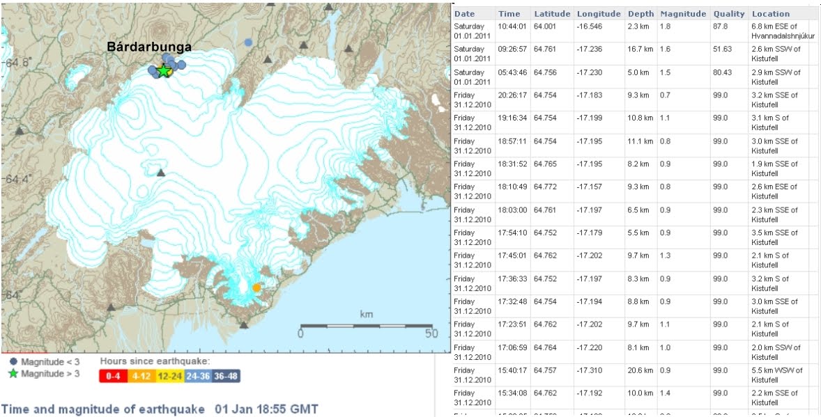
There's been a lot of media interest in Bárðarbunga recently, and I've posted the two screengrabs from the Icelandic Met Office Earthquake web site. The top picture was a record of recent tremor activity from 6th January 2011. The lower was snapped today. I've annotated it with rough approximations of where various volcanoes are, and what was happening today. Not a lot is the answer. Which of course doesn't make very good copy, but it is accurate.

What does this portend? We don't know.

Update: The man whose quotation began the scare, Dr Pall Einarsson, is also quite rightly annoyed about how his interview has been twisted in the lamestream media. A classic demonstration of how the search for dramatic 'stories' can make black look white and conjure non-existent bogeymen out of the slightest shadow.

Tuesday, 8 February 2011

Bárðarbunga observations

According to this story in the Tellytubbygraph, Dr Pall Einarsson, a professor of geophysics since 1999 at the University of Iceland has said that Bárðarbunga is next on the list of big eruptions.

Having gone through my catalogue of screengrabs for Vatnajokull, I've noted a lot of swarm like activity reported in the Bárðarbunga area around the 5-14km depth range on the following dates since April 2010. 28th May 2010, 26th September 2010, 1st January 2011 and 7th February 2011. Screengrabs reposted below.


There have been a number of similar 'deep swarm' type activity events observed in the same time period along the mid Atlantic spreading zone as it passes through Iceland. Approximate locations from North to South;
1) Tjörnes fracture zone 10-13km NE of Grimsey
2) Loki area, Vatnajokull
3) Krisuvik area, Rekjanes peninsula
All are on the mid Atlantic fault and have been displaying similar swarm activity periodically since I started my observations back in April 2010.

As I am fond of saying; the usual caveats about tremors alone apply. Like Dr Einarsson, I wish there was more data available re ground deformation etc which might give better warning of an eruption and so reduce the guesswork, and therefore the possible damage and disruption.

Volcanoes erupt. It is what they do. It would be helpful if we knew more about when and how big.

Sunday, 6 February 2011

Vatnajökull activity


Dropped by the Icelandic Met office earthquake site for my daily dose of Earth tremors and noted that there's been some fairly shallow activity underneath Grimsvotn, which may mean another minor eruption due, but as usual my caveat about tremor activity alone applies. Lot of fairly deep rumblings under Bárðarbunga, which generally speaking don't mean a lot since they're right in the Mid Atlantic spreading zone. Which is where you'd expect a lot of tremor activity as continual upwellings of magma fill the gap between diverging tectonic plates.

Nothing much happening around Katla, apart from one very small tremor, and nothing else appears to be sizing up for a blow. Although I'm only a dilettante vulcanologist, so what do I know? As always I'm simply an interested observer.

Wednesday, 26 January 2011

New link

For those of you who share my interest in matters volcanic, I've added this link from NASA's Earth observatory to the sidebar under Some Climate and Volcano Links.

While everything seems relatively quiet on the Icelandic front, there's still a number of active eruptions going on at any given time. I find it fascinating, and for those that don't; this ain't your blog chummy.
Related Posts with Thumbnails